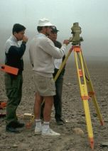
The second Expedition 1996
In summer 1996 members of our association and employees of the University
of Applied Sciences Dresden got ready for a second measuring campaign in the
desert of Nasca. With GPS measurments they fixed 19 linecentres – points,
where different lines and areas cross each other. Also they took nine well-known
geoglyphs with the help of a tacheometer.
Within the context of a diploma thesis at the faculty of Surveying and Cartography at
the University of Applied Sciences Dresden the measurement results were utilized.
The comparison of these results with the measurements of Maria Reiche produced a
good agreement.
Unfortunately, younger destructions were detected, which are not in the Maria’s drawings.
Besides the work in the Pampa, they made more preparations and contract negotiations
for the aerial photo flight. But for financial reasons they couldn’t realise this flight.
|