![]()
Association "Dr. Maria Reiche - Lines and Figures of the Nasca Culture/Peru"
![]()
![]()
![]()
![]()
![]()
![]()
![]()
![]()
![]()
![]()
Nascaproject |
Expeditions |
Photogrammetry |
Remote Sensing |
Terrain model |
NascaGIS |
Astronomy |
Animations |
Archives |
Theses |
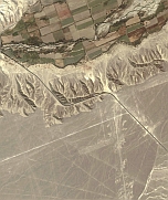
Remote SensingThe available photogrammetric data covers only the main area of the Pampa of Nasca. For this reason the use of satellite data is an alternative to capture vector data in the remaining region. Therefore we’ve bought high-resolution satellite data of the entire area. The main region is covered with IKONOS data (1 m resolution) and/or Quickbird data with a resolution of 0.6 m. Only in the northern part (near Palpa) we've got GeoEye data (resolution 0.5 m).To rectify these images, ground control points (GCP's) are necessary. Therefore several GPS campaigns were organized during the last years.
|